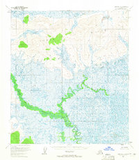
1954 Map of Ophir D-4
USGS Topo · Published 1965About this map
Tolat Hills dominate the northern landscape of this interior Alaska region, rising above a vast network of wetlands and meandering waterways. The Dishkaket River winds through the southern half of the territory, defined by intricate oxbows and seasonal flood patterns that speak to the ever-shifting nature of the terrain. The hydrological complexity is further detailed by the confluence of the Little Mud River and Gatalee Creek, which drain the surrounding lowlands. Based on aerial photography from 1953, the map illustrates an era before significant modern infrastructure, focusing entirely on the natural landforms and traditional water routes used for navigation and subsistence in the Yukon-Koyukuk region.
Find a feature on this map
4 named features on this map. Tap any name to fly to it.
Don’t see what you’re looking for? This feature index may not catch every label — zoom into the map to look around manually.
Map Details
Editions of this 1954 Ophir D-4 Map
This is the sole edition of this map. No revisions or reprints were ever made.
Other maps of this area

1945 · Nulato
USGS Topo · 1:250,000

1951 · Ophir
USGS Topo · 1:250,000

1951 · Nulato
USGS Topo · 1:250,000

1952 · Nulato A-5
USGS Topo · 1:63,360

1952 · Nulato A-4
USGS Topo · 1:63,360

1952 · Nulato A-3
USGS Topo · 1:63,360

1952 · Nulato
USGS Topo · 1:250,000
1953 · Nulato A-4
USGS Topo · 1:63,360
1954 · Ophir D-5
USGS Topo · 1:63,360

1954 · Ophir C-5
USGS Topo · 1:63,360