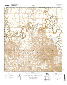
2014 Map of Ophir C-5 SW
USGS Topo · Published 2014About this map
Magitchlie Creek and its complex meandering tributaries dominate this portion of the interior, illustrating the dynamic hydrology of the Alaskan wilderness. The landscape is defined by the sinuous path of Hather Creek and North Hather Creek, which cut through a terrain of low-lying wetlands and varied elevations. This 2014 study by the U.S. Geological Survey provides a precise topographic record of the drainage patterns and township boundaries within the t21s r2e and t22s r3e sections. The absence of roads or established settlements emphasizes the undisturbed natural state of this region, where the network of creeks serves as the primary geographical defining features for researchers and outdoorsmen tracking the hydrological evolution of the Yukon-Koyukuk territory.
Find a feature on this map
9 named features on this map. Tap any name to fly to it.
Don’t see what you’re looking for? This feature index may not catch every label — zoom into the map to look around manually.
Map Details
Editions of this 2014 Ophir C-5 SW Map
This is the sole edition of this map. No revisions or reprints were ever made.
Other maps of this area

1951 · Ophir
USGS Topo · 1:250,000

1954 · Ophir C-6
USGS Topo · 1:63,360

1954 · Ophir C-5
USGS Topo · 1:63,360
1954 · Ophir B-6
USGS Topo · 1:63,360

1954 · Ophir B-5
USGS Topo · 1:63,360

1954 · Ophir
USGS Topo · 1:250,000
2014 · Ophir C-6 SE
USGS Topo · 1:25,000
2014 · Ophir C-6 NE
USGS Topo · 1:25,000
2014 · Ophir B-6 NE
USGS Topo · 1:25,000
2014 · Ophir B-5 NW
USGS Topo · 1:25,000