
1954 Map of Ophir B-5
USGS Topo · Published 1965About this map
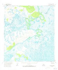
The Innoko River dominates this interior Alaskan landscape, shown here as a complex series of tight meanders and oxbow lakes winding through a vast wetland system. Mapped using photogrammetric methods from 1953 aerial photography, the sheet reveals a wilderness of low relief where the river’s path is the primary geographical anchor. To the northeast, the smaller Hammer Creek feeds into the surrounding swamp. The topography indicates significant areas of wet terrain and occasional upland rises, though no permanent human settlements or roads appear in this portion of the Kateel River Meridian. The lack of infrastructure highlights the isolation of this region during the mid-1950s, serving as a record of the unsurveyed and unmarked locations as they existed before modern development or formal land division by the Bureau of Land Management.
Find a feature on this map
2 named features on this map. Tap any name to fly to it.
Don’t see what you’re looking for? This feature index may not catch every label — zoom into the map to look around manually.
Map Details
Editions of this 1954 Ophir B-5 Map
2 editions found
Other maps of this area

1951 · Ophir
USGS Topo · 1:250,000

1954 · Ophir A-6
USGS Topo · 1:63,360

1954 · Ophir A-5
USGS Topo · 1:63,360

1954 · Ophir C-6
USGS Topo · 1:63,360

1954 · Ophir C-5
USGS Topo · 1:63,360

1954 · Ophir A-4
USGS Topo · 1:63,360

1954 · Ophir B-4
USGS Topo · 1:63,360
1954 · Ophir B-6
USGS Topo · 1:63,360

1954 · Ophir C-4
USGS Topo · 1:63,360

1954 · Ophir
USGS Topo · 1:250,000