
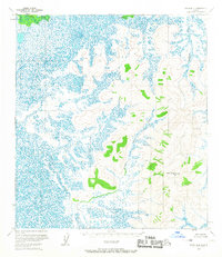
1954 Map of Ophir B-4
USGS Topo · Published 1965About this map
Old Grouch Top and its surrounding peaks stand above a massive network of wetlands and meandering waterways in this mid-century topographic study. The landscape is defined by the sharp contrast between the elevated terrain of Blazo and Grouch and the intricate, swampy lowlands of the western half. These unnamed marshes, surveyed via aerial photography in the early 1950s, represent the complex drainage patterns of the Alaskan interior where Hammer Creek flows through the northern reaches. The survey captures a moment when the Bureau of Land Management had established predetermined but unsurveyed land lines, marking a transition toward formalizing legal boundaries in a region where few permanent roads or trails existed at the time of the field annotation. Local named landmarks like Punk and Mound provide critical orientation points within this expansive wilderness.
Find a feature on this map
7 named features on this map. Tap any name to fly to it.
Don’t see what you’re looking for? This feature index may not catch every label — zoom into the map to look around manually.
Map Details
Editions of this 1954 Ophir B-4 Map
2 editions found
Other maps of this area

1951 · Ophir
USGS Topo · 1:250,000

1954 · Ophir A-5
USGS Topo · 1:63,360

1954 · Ophir C-5
USGS Topo · 1:63,360

1954 · Ophir C-3
USGS Topo · 1:63,360

1954 · Ophir A-3
USGS Topo · 1:63,360

1954 · Ophir A-4
USGS Topo · 1:63,360

1954 · Ophir B-3
USGS Topo · 1:63,360

1954 · Ophir B-5
USGS Topo · 1:63,360

1954 · Ophir C-4
USGS Topo · 1:63,360

1954 · Ophir
USGS Topo · 1:250,000