
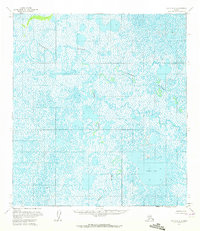
1954 Map of Ophir A-5
USGS Topo · Published 1964About this map
The Iditarod River meanders across this interior landscape, forming an intricate network of oxbows and sloughs that define the region's hydrology. This mid-century survey by the Usgs uses photogrammetric methods to capture a vast wetland environment where water and land are in constant flux. In the southeastern portion of the map, Sixmile Lake stands as a significant landmark amidst a mosaic of smaller unnamed ponds and marshy reaches. The Yetna River joins the drainage system from the south, illustrating the natural watercourses that historically served as the primary transit corridors through this part of the Alaska interior. The absence of roads or established settlements on this sheet emphasizes the wilderness character of the terrain, where river navigation and seasonal changes dictate the movement of people and wildlife.
Find a feature on this map
3 named features on this map. Tap any name to fly to it.
Don’t see what you’re looking for? This feature index may not catch every label — zoom into the map to look around manually.
Map Details
Editions of this 1954 Ophir A-5 Map
2 editions found
Other maps of this area

1951 · Ophir
USGS Topo · 1:250,000

1951 · Iditarod
USGS Topo · 1:250,000

1954 · Ophir A-6
USGS Topo · 1:63,360

1954 · Iditarod D-6
USGS Topo · 1:63,360

1954 · Iditarod D-5
USGS Topo · 1:63,360

1954 · Ophir A-4
USGS Topo · 1:63,360

1954 · Ophir B-4
USGS Topo · 1:63,360

1954 · Iditarod D-4
USGS Topo · 1:63,360
1954 · Ophir B-6
USGS Topo · 1:63,360

1954 · Ophir B-5
USGS Topo · 1:63,360