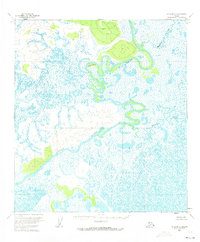
1954 Map of Ophir B-5
USGS Topo · Published 1973About this map
Innoko River meanders through this interior Alaska landscape, defining a complex network of oxbow lakes, sloughs, and marshlands. Mapped by the Geological Survey using 1953 aerial photography, the region is characterized by its dramatic hydrological patterns and minimal human footprint. The map shows the winding course of the river as it flows southwest, joined by smaller tributaries such as Hammer Creek in the northeast and Grouch Creek further south. These waterways represent the primary landmarks in an unsurveyed wilderness where land lines were predetermined by the Bureau of Land Management rather than marked on the ground. The prevalence of wetter areas and low relief highlights the challenges of navigating this Kateel River Meridian territory during the mid-twentieth century.
Find a feature on this map
3 named features on this map. Tap any name to fly to it.
Don’t see what you’re looking for? This feature index may not catch every label — zoom into the map to look around manually.
Map Details
Editions of this 1954 Ophir B-5 Map
2 editions found
Other maps of this area

1951 · Ophir
USGS Topo · 1:250,000

1954 · Ophir A-6
USGS Topo · 1:63,360

1954 · Ophir A-5
USGS Topo · 1:63,360

1954 · Ophir C-6
USGS Topo · 1:63,360

1954 · Ophir C-5
USGS Topo · 1:63,360

1954 · Ophir A-4
USGS Topo · 1:63,360

1954 · Ophir B-4
USGS Topo · 1:63,360
1954 · Ophir B-6
USGS Topo · 1:63,360

1954 · Ophir B-5
USGS Topo · 1:63,360

1954 · Ophir C-4
USGS Topo · 1:63,360