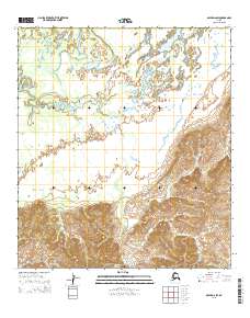
2015 Map of Ophir D-6 SW
USGS Topo · Published 2015About this map
The remote interior of Alaska's Yukon-Koyukuk region is defined by a landscape of extreme transitions, where low-lying drainage basins meet rising upland terrain. This 2015 survey reveals an area largely untouched by modern infrastructure, mapped according to the Public Land Survey System boundaries of T19s R1w and T19s R2w. The northern sections of the map are dominated by meandering watercourses and wetlands, while the southern reaches transition into more complex elevation contours as the land gains height toward the eastern limits of T19s R1e. Without named settlements or roads, the map serves as a primary record of the natural topography and the precisely surveyed township lines, including T20s R1w and T20s R2w, which govern this wilderness. It is an essential document for understanding the geographic layout of the Ophir quadrangle before any significant human development altered the terrain.
Find a feature on this map
6 named features on this map. Tap any name to fly to it.
Don’t see what you’re looking for? This feature index may not catch every label — zoom into the map to look around manually.
Map Details
Editions of this 2015 Ophir D-6 SW Map
This is the sole edition of this map. No revisions or reprints were ever made.
Other maps of this area

1951 · Ophir
USGS Topo · 1:250,000

1951 · Unalakleet
USGS Topo · 1:250,000

1952 · Unalakleet C-1
USGS Topo · 1:63,360

1952 · Unalakleet D-1
USGS Topo · 1:63,360

1952 · Unalakleet
USGS Topo · 1:250,000
1954 · Ophir D-6
USGS Topo · 1:63,360

1954 · Ophir C-6
USGS Topo · 1:63,360

1954 · Ophir
USGS Topo · 1:250,000

1964 · Unalakleet
USGS Topo · 1:250,000
2014 · Ophir D-6 SE
USGS Topo · 1:25,000