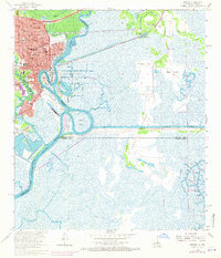
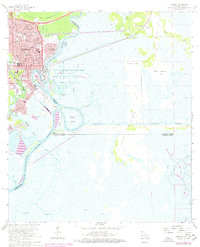
1960 Map of Orange
USGS Topo · Published 1971About this map
The Sabine River snakes through the heart of this coastal border region, defining the intricate water-based industry of Orange and its surrounding communities. In the early 1960s, the landscape is a complex network of man-made cuts and natural bayous, with the U S Naval Station and the Turning Basin highlighting the area's maritime importance. Dense residential neighborhoods in Brownwood and West Orange contrast with the expansive marshes and islands to the east, such as Pavell Island and Big Island. Local life is anchored by numerous institutions, including St Marys High Sch, the Hebrew Cem, and Evergreen Cem. The convergence of the Southern Pacific railroad and the Intracoastal Waterway illustrates a mid-century hub where rail and river traffic met to drive the local economy.
Find a feature on this map
60 named features on this map. Tap any name to fly to it.
Don’t see what you’re looking for? This feature index may not catch every label — zoom into the map to look around manually.
Map Details
Editions of this 1960 Orange Map
5 editions found
Other maps of this area

1926 · Mauriceville
USGS Topo · 1:24,000

1932 · Orange
USGS Topo · 1:62,500

1932 · Port Arthur NE
USGS Topo · 1:31,680

1934 · Greens Bayou
USGS Topo · 1:24,000

1934 · Five Lakes
USGS Topo · 1:24,000

1935 · Five Lakes
USGS Topo · 1:31,680

1935 · Greens Bayou
USGS Topo · 1:31,680

1943 · West of Greens Bayou
USGS Topo · 1:24,000

1943 · Orangefield
USGS Topo · 1:24,000

1943 · Mauriceville
USGS Topo · 1:24,000