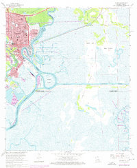
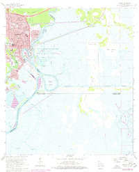
1960 Map of Orange
USGS Topo · Published 1976About this map
The Sabine River serves as the dominant industrial and geographical artery for this borderland, where the urban grid of Orange meets the sprawling marshlands of Louisiana. During this mid-century period, the landscape reflects a complex economy of maritime defense and energy extraction, centered on the U S Naval Station and the Phoenix Lake Oil Field. While the Texas side is densely packed with civic infrastructure like the St Marys Church, Evergreen Cem, and numerous schools, the eastern reaches in Calcasieu Parish remain largely defined by natural water features such as Blue Lake and Tupelo Swamp. The intricate network of the Intracoastal Waterway and various cuts, like the Berwick Cut, highlight the region's total reliance on waterborne commerce and its evolving industrial shoreline.
Find a feature on this map
63 named features on this map. Tap any name to fly to it.
Don’t see what you’re looking for? This feature index may not catch every label — zoom into the map to look around manually.
Map Details
Editions of this 1960 Orange Map
5 editions found
Other maps of this area

1926 · Mauriceville
USGS Topo · 1:24,000

1932 · Orange
USGS Topo · 1:62,500

1932 · Port Arthur NE
USGS Topo · 1:31,680

1934 · Greens Bayou
USGS Topo · 1:24,000

1934 · Five Lakes
USGS Topo · 1:24,000

1935 · Five Lakes
USGS Topo · 1:31,680

1935 · Greens Bayou
USGS Topo · 1:31,680

1943 · West of Greens Bayou
USGS Topo · 1:24,000

1943 · Orangefield
USGS Topo · 1:24,000

1943 · Mauriceville
USGS Topo · 1:24,000