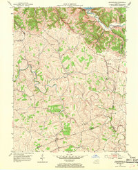
1952 Map of Orangeburg
USGS Topo · Published 1969About this map
The Ohio River forms the northern boundary of this Kentucky landscape, which transitions quickly from the river valley into a dissected plateau of ridges and hollows. Small upland settlements like Orangeburg and Plumville serve as local hubs for the surrounding farmsteads. The drainage pattern is dominated by the winding course of the North Fork Licking River and Cabin Creek, which have carved deep valleys that dictate the placement of local roads and property lines.
Find a feature on this map
32 named features on this map. Tap any name to fly to it.
Don’t see what you’re looking for? This feature index may not catch every label — zoom into the map to look around manually.
Map Details
Editions of this 1952 Orangeburg Map
3 editions found
Other maps of this area

1915 · Maysville
USGS Topo · 1:62,500

1919 · Maysville
USGS Topo · 1:62,500

1929 · Springdale
USGS Topo · 1:48,000

1935 · Springdale
USGS Topo · 1:62,500

1951 · Burtonville
USGS Topo · 1:24,000

1951 · Flemingsburg
USGS Topo · 1:24,000

1952 · Maysville East
USGS Topo · 1:24,000

1952 · Elizaville
USGS Topo · 1:24,000

1952 · Maysville West
USGS Topo · 1:24,000
1952 · Orangeburg
USGS Topo · 1:24,000