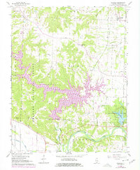
1968 Map of Oraville
USGS Topo · Published 1978About this map
The Big Muddy River winds through the southern landscape of this 1960s survey, marking a distinct border near the Missouri Pacific and Illinois Central Gulf rail lines. This period is defined by the significant expansion of Kinkaid Lake within the Shawnee National Forest, where purple photorevised updates from 1978 show the rising waters following the construction of the Crisenberry Dam. Small rural communities and agrarian roots are evident through numerous family-named burial grounds like Bartlett Cem and Lone Oak Cem.
Find a feature on this map
34 named features on this map. Tap any name to fly to it.
Don’t see what you’re looking for? This feature index may not catch every label — zoom into the map to look around manually.
Map Details
Editions of this 1968 Oraville Map
3 editions found
Other maps of this area

1910 · Murphysboro
USGS Topo · 1:62,500

1916 · Campbell Hill
USGS Topo · 1:62,500

1918 · Altenburg
USGS Topo · 1:62,500

1918 · Campbell Hill
USGS Topo · 1:62,500

1924 · Alto Pass
USGS Topo · 1:62,500

1925 · Altenburg
USGS Topo · 1:62,500

1938 · Murphysboro
USGS Topo · 1:62,500

1947 · Alto Pass
USGS Topo · 1:62,500

1947 · Gorham
USGS Topo · 1:24,000

1947 · Altenburg
USGS Topo · 1:62,500