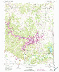
1968 Map of Oraville
USGS Topo · Published 1990About this map
Kinkaid Lake dominates the central landscape of this 1968 survey, its jagged shoreline and recreation areas like Buttermilk Hill Beach and Picnic Area representing a significant transformation of the local topography. This map captures the area during a period of transition, where the natural flow of Kinkaid Creek has been altered by the construction of Crisenberry Dam. The southern portion is defined by the alluvial flats of the Big Muddy River, featuring Sand Ridge and a section of dismantled railroad that once served the river valley's industry.
Find a feature on this map
38 named features on this map. Tap any name to fly to it.
Don’t see what you’re looking for? This feature index may not catch every label — zoom into the map to look around manually.
Map Details
Editions of this 1968 Oraville Map
3 editions found
Other maps of this area

1910 · Murphysboro
USGS Topo · 1:62,500

1916 · Campbell Hill
USGS Topo · 1:62,500

1918 · Altenburg
USGS Topo · 1:62,500

1918 · Campbell Hill
USGS Topo · 1:62,500

1924 · Alto Pass
USGS Topo · 1:62,500

1925 · Altenburg
USGS Topo · 1:62,500

1938 · Murphysboro
USGS Topo · 1:62,500

1947 · Alto Pass
USGS Topo · 1:62,500

1947 · Gorham
USGS Topo · 1:24,000

1947 · Altenburg
USGS Topo · 1:62,500