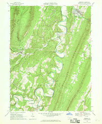
1966 Map of Orbisonia
USGS Topo · Published 1969About this map
Orbisonia and Rockhill anchor the northeast corner of this mid-1960s survey, situated along the winding path of Blacklog Creek. The landscape is dominated by the linear ridges of the Ridge-and-Valley Appalachians, including Jacks Mountain, Shade Mountain, and Blacklog Mountain. Between these heights, small rural communities like Pogue and Three Springs follow the watercourses and gaps that historically dictated travel and settlement in Huntingdon County.
Find a feature on this map
57 named features on this map. Tap any name to fly to it.
Don’t see what you’re looking for? This feature index may not catch every label — zoom into the map to look around manually.
Map Details
Editions of this 1966 Orbisonia Map
3 editions found
Other maps of this area

1901 · Huntingdon
USGS Topo · 1:62,500

1904 · Huntingdon
USGS Topo · 1:62,500

1922 · Mt Union
USGS Topo · 1:48,000

1924 · Mt. Union
USGS Topo · 1:62,500

1930 · Broad Top
USGS Topo · 1:62,500

1933 · Broad Top
USGS Topo · 1:62,500

1939 · Orbisonia
USGS Topo · 1:62,500

1940 · Orbisonia
USGS Topo · 1:62,500

1944 · Orbisonia
USGS Topo · 1:62,500

1944 · Mt. Union
USGS Topo · 1:62,500