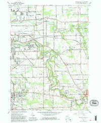
1965 Map of Orchard Park
USGS Topo · Published 1988About this map
Cazenovia Creek and Buffalo Creek define the landscape of eastern Erie County in the mid-1960s, winding through growing suburban settlements. The area shows a transition from agricultural use to institutional and residential development, anchored by major sites like the West Seneca State School and St John Vianney Seminary. Local aviation history is well-represented by the Buffalo Airpark, Orchard Park Airport, and Proner Airport, reflecting the era's infrastructure needs. The map records numerous smaller communities such as New Ebenezer, Blossom, and Spring Brook, along with specialized landmarks like the Pet Cem and Orchard Park Country Club. The rail network of the Pennsylvania RR and Baltimore and Ohio RR remains a prominent feature, cutting across the creek valleys and connecting these established towns and hamlets.
Find a feature on this map
75 named features on this map. Tap any name to fly to it.
Don’t see what you’re looking for? This feature index may not catch every label — zoom into the map to look around manually.
Map Details
Editions of this 1965 Orchard Park Map
4 editions found
Other maps of this area

1894 · Buffalo
USGS Topo · 1:62,500

1901 · Buffalo
USGS Topo · 1:62,500

1905 · Depew
USGS Topo · 1:62,500

1905 · Eden
USGS Topo · 1:62,500

1907 · Eden
USGS Topo · 1:62,500

1925 · Springville
USGS Topo · 1:62,500

1944 · Eden
USGS Topo · 1:62,500

1944 · Hamburg
USGS Topo · 1:31,680

1948 · Hamburg
USGS Topo · 1:24,000

1948 · Depew
USGS Topo · 1:62,500