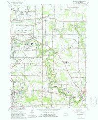
1965 Map of Orchard Park
USGS Topo · Published 1988About this map
The suburban and rural landscape of Erie County is captured here as residential growth began to interface with established agriculture and aviation. West Seneca State School occupies a prominent central tract, while the surrounding area is punctuated by specialized infrastructure including the Buffalo Airpark, Conley Airfield, and Orchard Park Airport. These small airfields, alongside the Pennsylvania and Baltimore and Ohio railroads, illustrate a region in transition, serving both local industry and the expanding needs of the Buffalo metropolitan area.
Find a feature on this map
69 named features on this map. Tap any name to fly to it.
Don’t see what you’re looking for? This feature index may not catch every label — zoom into the map to look around manually.
Map Details
Editions of this 1965 Orchard Park Map
4 editions found
Other maps of this area

1894 · Buffalo
USGS Topo · 1:62,500

1901 · Buffalo
USGS Topo · 1:62,500

1905 · Depew
USGS Topo · 1:62,500

1905 · Eden
USGS Topo · 1:62,500

1907 · Eden
USGS Topo · 1:62,500

1925 · Springville
USGS Topo · 1:62,500

1944 · Eden
USGS Topo · 1:62,500

1944 · Hamburg
USGS Topo · 1:31,680

1948 · Hamburg
USGS Topo · 1:24,000

1948 · Depew
USGS Topo · 1:62,500