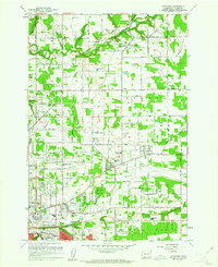
1961 Map of Orchards
USGS Topo · Published 1961About this map
Fourth Plains and Mill Plain characterize this 1961 view of Clark County, documenting an era of suburban expansion and agricultural persistence. The landscape is bisected by the Northern Pacific railroad, which links established communities like Brush Prairie and Orchards. Local history is deeply etched into the grid by numerous family and community landmarks, including Wilson Cem, Elim Cem, and St Johns Cem, alongside the extensive grounds of Evergreen Memorial Gardens.
Find a feature on this map
44 named features on this map. Tap any name to fly to it.
Don’t see what you’re looking for? This feature index may not catch every label — zoom into the map to look around manually.
Map Details
Editions of this 1961 Orchards Map
4 editions found
Other maps of this area

1897 · Portland
USGS Topo · 1:62,500

1905 · Portland
USGS Topo · 1:62,500

1918 · Troutdale
USGS Topo · 1:62,500

1934 · Troutdale
USGS Topo · 1:48,000

1940 · Portland
USGS Topo · 1:62,500

1940 · La Center
USGS Topo · 1:62,500

1941 · Yacolt
USGS Topo · 1:62,500

1941 · Camas
USGS Topo · 1:62,500

1942 · Camas
USGS Topo · 1:62,500

1948 · Vancouver
USGS Topo · 1:250,000