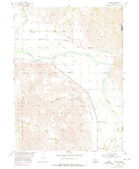
1954 Map of Ord SE
USGS Topo · Published 1978About this map
The North Loup River valley dominates this 1950s landscape, serving as the central artery for both natural drainage and human industry. Irrigation infrastructure is highly developed, evidenced by the North Loup Canal winding through the basin to support the agricultural productivity of the Springdale and North Loup townships. This era shows a community tightly linked by education and rail, with rural schools like Springdale Sch and Maiden Valley Sch serving dispersed farmsteads between the river and the broken terrain of McDowell Canyon.
Find a feature on this map
21 named features on this map. Tap any name to fly to it.
Don’t see what you’re looking for? This feature index may not catch every label — zoom into the map to look around manually.
Map Details
Editions of this 1954 Ord SE Map
3 editions found
Other maps of this area

1899 · Loup
USGS Topo · 1:125,000

1953 · Loup City NW
USGS Topo · 1:24,000

1953 · North Loup
USGS Topo · 1:24,000

1953 · Scotia
USGS Topo · 1:24,000

1954 · Ord SE
USGS Topo · 1:24,000

1954 · Ord
USGS Topo · 1:24,000

1954 · Ord NE
USGS Topo · 1:24,000

1954 · Horace
USGS Topo · 1:24,000

1954 · Ord NW
USGS Topo · 1:24,000

1954 · Greeley NW
USGS Topo · 1:24,000