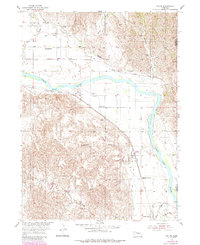
1954 Map of Ord SE
USGS Topo · Published 1985About this map
The North Loup River valley dominates this mid-century survey of Nebraska's farming heartland, showing a landscape defined by its waterways and rail connections. The Union Pacific line cuts through the southern terrain, connecting the settlement of North Loup with the surrounding countryside, while an Old Railroad Grade further north near Sumter and Spelts marks a shift in the region's transport infrastructure. This area, mapped for the development of the Missouri River Basin, reveals a high density of rural education centers, including Springdale Sch, Olean Sch, and Highway View Sch, highlighting the importance of local schools to the distributed agricultural community. Rugged terrain features such as McDowell Canyon and Elm Creek contrast with the flat river valley, where seasonal drainage via Spring Creek and Mira Creek supports the fertile valley floor.
Find a feature on this map
17 named features on this map. Tap any name to fly to it.
Don’t see what you’re looking for? This feature index may not catch every label — zoom into the map to look around manually.
Map Details
Editions of this 1954 Ord SE Map
3 editions found
Other maps of this area

1899 · Loup
USGS Topo · 1:125,000

1953 · Loup City NW
USGS Topo · 1:24,000

1953 · North Loup
USGS Topo · 1:24,000

1953 · Scotia
USGS Topo · 1:24,000

1954 · Ord SE
USGS Topo · 1:24,000

1954 · Ord
USGS Topo · 1:24,000

1954 · Ord NE
USGS Topo · 1:24,000

1954 · Horace
USGS Topo · 1:24,000

1954 · Ord NW
USGS Topo · 1:24,000

1954 · Greeley NW
USGS Topo · 1:24,000