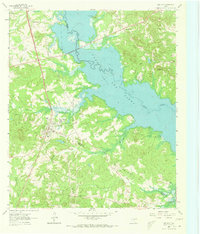
1962 Map of Ore City
USGS Topo · Published 1973About this map
Ore City serves as the primary hub of this East Texas landscape, where the convergence of Upshur, Marion, and Harrison counties meets the rising waters of Lake O' the Pines. The map captures the area just as the impoundment of Big Cypress Creek transformed the topography, creating an intricate shoreline dotted with recreation sites like Warners Landing Campground and Pope Landing Campgrounds. Inland, the traditional social fabric of the region is visible through landmarks such as Duncan Jr High Sch, Cedar Grove Cem, and Piney Grove Ch. Significant for researchers is the marking of an Old Grade and various gravel operations, reflecting the transit and industrial history of the Piney Woods. The presence of the Mims Chapel Lookout Tower overlooks the wooded hills and the expanding reservoir, highlighting the transition from a river-bottom economy to one centered on water management and recreation.
Find a feature on this map
29 named features on this map. Tap any name to fly to it.
Don’t see what you’re looking for? This feature index may not catch every label — zoom into the map to look around manually.
Map Details
Editions of this 1962 Ore City Map
Other maps of this area

1956 · Tyler
USGS Topo · 1:250,000

1960 · Coffeeville
USGS Topo · 1:24,000

1960 · Glenwood
USGS Topo · 1:24,000

1960 · La Fayette
USGS Topo · 1:24,000

1961 · Lassater
USGS Topo · 1:24,000

1961 · Harleton
USGS Topo · 1:24,000

1962 · Ashland
USGS Topo · 1:24,000

1962 · Avinger
USGS Topo · 1:24,000

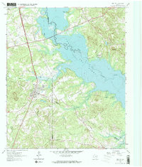
1962 · Ore City
USGS Topo · 1:24,000

1962 · Lone Star
USGS Topo · 1:24,000