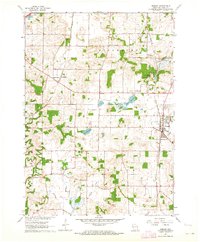
1961 Map of Oregon
USGS Topo · Published 1964About this map
The town of Oregon serves as a focal point in this early 1960s survey of southern Dane County, where the Chicago and North Western railway cuts through the landscape. The geography is defined by glacial features, including the Barney Swamp and Lake Barney, alongside smaller kettle lakes like Goose Lake and Lake Harriett. To the north, the burgeoning community of Fitchburg is visible near the Illinois Central tracks, illustrating the transition between mid-century agriculture and growing suburban corridors.
Find a feature on this map
32 named features on this map. Tap any name to fly to it.
Don’t see what you’re looking for? This feature index may not catch every label — zoom into the map to look around manually.
Map Details
Editions of this 1961 Oregon Map
4 editions found
Other maps of this area

1889 · Evansville
USGS Topo · 1:62,500

1890 · Madison
USGS Topo · 1:62,500

1892 · Madison
USGS Topo · 1:62,500

1894 · Evansville
USGS Topo · 1:62,500

1904 · Madison
USGS Topo · 1:62,500

1906 · Evansville
USGS Topo · 1:62,500

1906 · Madison
USGS Topo · 1:62,500

1907 · Cross Plains
USGS Topo · 1:62,500

1909 · Cross Plains
USGS Topo · 1:62,500

1923 · New Glarus
USGS Topo · 1:62,500