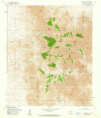
1955 Map of Organ Peak
USGS Topo · Published 1962About this map
The Organ Mountains dominate this mid-century landscape, characterized by dramatic vertical relief and high-altitude peaks such as Rabbit Ears, The Needles, and Organ Needle. This territory serves as a significant intersection of defense and natural topography, with large portions of the terrain encompassed by the Fort Bliss Military Reservation and the White Sands Proving Ground. Local infrastructure at this time was sparse, centered around the airstrip and Hayner Resort tucked below the high peaks.
Find a feature on this map
56 named features on this map. Tap any name to fly to it.
Don’t see what you’re looking for? This feature index may not catch every label — zoom into the map to look around manually.
Map Details
Editions of this 1955 Organ Peak Map
Other maps of this area

1891 · Las Cruces
USGS Topo · 1:125,000

1893 · Las Cruces
USGS Topo · 1:125,000

1940 · Newman
USGS Topo · 1:62,500

1941 · Organ Peak
USGS Topo · 1:62,500

1943 · La Mesa
USGS Topo · 1:62,500

1943 · Parker Lake
USGS Topo · 1:62,500

1943 · Newman
USGS Topo · 1:62,500

1943 · Organ Peak
USGS Topo · 1:62,500

1948 · Davies Tank
USGS Topo · 1:24,000

1948 · Newman NW
USGS Topo · 1:24,000