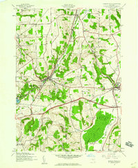
1943 Map of Oriskany Falls
USGS Topo · Published 1960About this map
Oriskany Creek defines the industrial and topographic spine of this region, carved into a valley where the New York Central railroad serves the village of Oriskany Falls. In the early 1940s, the landscape was a patchwork of active dairy farms and hamlets like Deansboro and Sangerfield. The map reveals the intricate social fabric of the day through its naming of several family and parish burial grounds, including O'Toole Cem and St Bernards Cem.
Find a feature on this map
42 named features on this map. Tap any name to fly to it.
Don’t see what you’re looking for? This feature index may not catch every label — zoom into the map to look around manually.
Map Details
Editions of this 1943 Oriskany Falls Map
3 editions found
Other maps of this area

1895 · Oriskany
USGS Topo · 1:62,500

1895 · Oneida
USGS Topo · 1:62,500

1898 · Oneida
USGS Topo · 1:62,500

1898 · Oriskany
USGS Topo · 1:62,500

1902 · Morrisville
USGS Topo · 1:62,500

1902 · Oneida
USGS Topo · 1:62,500

1907 · Sangerfield
USGS Topo · 1:62,500

1939 · Oneida
USGS Topo · 1:62,500

1943 · Hubbardsville
USGS Topo · 1:24,000

1943 · Cassville
USGS Topo · 1:24,000