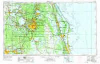
1955 Map of Orlando
USGS Topo · Published 1975About this map
Central Florida’s mid-century expansion is charted here during a transformative era for the Space Coast and the burgeoning tourism industry. Orlando serves as the inland hub, surrounded by the established citrus and lake country of Winter Park, Sanford, and Leesburg. The landscape is fundamentally changing with the emergence of Walt Disney World and a massive military footprint, including the Orlando Naval Training Device Center, Orlando AFB, and Mc Coy AFB.
Find a feature on this map
256 named features on this map. Tap any name to fly to it.
Don’t see what you’re looking for? This feature index may not catch every label — zoom into the map to look around manually.
Map Details
Editions of this 1955 Orlando Map
3 editions found

Other maps of this area

1893 · Panasoffkee
USGS Topo · 1:62,500

1895 · Panasoffkee
USGS Topo · 1:62,500

1895 · Ocala
USGS Topo · 1:62,500

1937 · Port Orange
USGS Topo · 1:48,000

1943 · Port Orange
USGS Topo · 1:62,500

1944 · Plant City
USGS Topo · 1:31,680

1944 · Providence
USGS Topo · 1:31,680

1944 · Polk City
USGS Topo · 1:31,680

1944 · Lakeland
USGS Topo · 1:31,680

1944 · Auburndale
USGS Topo · 1:31,680