1958 Map of Orlando
USGS Topo · Published 1958About this map
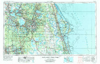
Orlando serves as the central hub of this mid-century portrait of Central Florida, a landscape defined by an immense network of freshwater basins and a growing military presence. To the east, the Atlantic coast features the critical installations of Patrick Air Force Base and the prominent geography of Cape Canaveral, while the interior is dominated by Lake Apoka and the sprawling Ocala National Forest. The region's mid-century economy and infrastructure are visible through the convergence of the Seaboard Air Line Railroad and Atlantic Coast Line Railroad, alongside the industrial presence of a Phosphate Mine near Lakeland.
Find a feature on this map
162 named features on this map. Tap any name to fly to it.
Don’t see what you’re looking for? This feature index may not catch every label — zoom into the map to look around manually.
Map Details
Editions of this 1958 Orlando Map
This is the sole edition of this map. No revisions or reprints were ever made.
Historical Maps of Oak Run Through Time
5 maps found