
Loading...
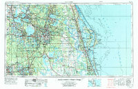
Loading map...1962 Map of Orlando
USGS Topo · Published 1962About this map
Orlando stands as the central hub of this Central Florida landscape during a period of rapid growth and aerospace expansion. Along the Atlantic coast, the significance of the Space Age is evident with the presence of Cape Canaveral and Patrick Air Force Base. The inland terrain is defined by a complex network of freshwater systems, including the massive Lake Apopka and the headwaters of the Saint Johns River, which flows through Lake Hellen Blazes and Sawgrass Lake.
Find a feature on this map
247 named features on this map. Tap any name to fly to it.
Don’t see what you’re looking for? This feature index may not catch every label — zoom into the map to look around manually.
Map Details
Date Portrayed1962
Date Published1962
PublisherU.S. Geological Survey
Map TypeTopographic
Scale1:250000
Physical Dimensions34 x 22 inches
Editions of this 1962 Orlando Map
This is the sole edition of this map. No revisions or reprints were ever made.
Historical Maps of Oak Run Through Time
5 maps found


Featured Locations
Source Details
SourceU.S. Geological Survey
CopyrightPublic Domain