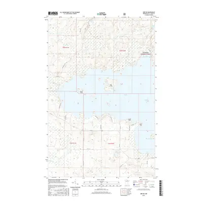
2016 Map of Orr SW
USGS Topo · Published 2016About this map
Superior National Forest encompasses a large portion of this northern landscape, where the waters of Pelican Lake dominate the central geography. This 2016 survey documents the intricate shoreline and numerous islands that define the lake's character, including Baileys Island and the centrally located Big Island. The map shows a region shaped by glacial depressions now filled by water bodies like Rabbit Lake, Swan Lake, and Gabrielson Lake, connected by smaller watercourses such as Swan Cr and Portage Cr. Human activity is concentrated along the lakefront, evidenced by a network of local access roads including Krullman Pt Rd and Grande's Point Rd that lead toward prominent landforms like Eagle Point and Elliott Point. In the south, the terrain levels out slightly as Prairie Cr winds through the wetlands, illustrating the transition between the dense forest and the expansive lake system.
Find a feature on this map
37 named features on this map. Tap any name to fly to it.
Don’t see what you’re looking for? This feature index may not catch every label — zoom into the map to look around manually.
Map Details
Editions of this 2016 Orr SW Map
This is the sole edition of this map. No revisions or reprints were ever made.
Other maps of this area
1954 · Hibbing
USGS Topo · 1:250,000

1954 · International Falls
USGS Topo · 1:250,000
1957 · Hibbing
USGS Topo · 1:250,000

1957 · International Falls
USGS Topo · 1:250,000

1958 · International Falls
USGS Topo · 1:250,000
1958 · Hibbing
USGS Topo · 1:250,000
1964 · Hibbing
USGS Topo · 1:250,000
1964 · Gheen NW
USGS Topo · 1:24,000
1964 · Gheen
USGS Topo · 1:24,000
1968 · Ash Lake
USGS Topo · 1:24,000