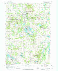
1968 Map of Ortonville
USGS Topo · Published 1974About this map
Glacial topography and a dense network of kettle lakes define the northern reaches of Oakland County as it appeared in the late 1960s and early 1970s. The village of Ortonville serves as the primary hub, surrounded by smaller residential developments such as Brandon Gardens and Perry Lake Heights. This era of the landscape is marked by the preservation of recreational lands within the Ortonville State Recreation Area and Holly State Recreation Area, contrasted against the residential growth spreading near Dixie Highway. Genealogists will find significant local value in the recorded locations of Carmer Cem, Eaton Cem, and the Springfield Plains Cem. The map meticulously tracks the headwaters of the Clinton River and the complex drainage of features like Bald Eagle Lake and Seymour Lake, providing a clear picture of the region's environmental and suburban development before later twentieth-century expansions.
Find a feature on this map
61 named features on this map. Tap any name to fly to it.
Don’t see what you’re looking for? This feature index may not catch every label — zoom into the map to look around manually.
Map Details
Editions of this 1968 Ortonville Map
3 editions found
Other maps of this area

1907 · Pontiac
USGS Topo · 1:62,500

1909 · Milford
USGS Topo · 1:62,500

1920 · Holly
USGS Topo · 1:62,500

1922 · Holly
USGS Topo · 1:62,500

1936 · Highland
USGS Topo · 1:31,680

1936 · Clarkston
USGS Topo · 1:31,680

1936 · Pontiac North
USGS Topo · 1:31,680

1942 · Highland
USGS Topo · 1:24,000

1943 · Holly
USGS Topo · 1:62,500

1943 · Clarkston
USGS Topo · 1:24,000
Featured Places
- Independence Charter Township, MI
- Springfield Charter Township, MI
- Ortonville, MI
- Brandon Charter Township, MI
- Groveland Township, MI