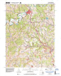
1997 Map of Osage
USGS Topo · Published 1999About this map
Mount Morris anchors the northern reaches of this landscape where Dunkard Creek winds across the state line between Pennsylvania and West Virginia. This late 1990s survey documents a terrain defined by narrow hollows and high ridges such as Sutton Knob and Higgins Knob. The southern portion of the sheet reveals the region's industrial character, with Strip Mines surrounding the mining-impacted communities of Osage, Jere, and Pursglove along Scotts Run.
Find a feature on this map
44 named features on this map. Tap any name to fly to it.
Don’t see what you’re looking for? This feature index may not catch every label — zoom into the map to look around manually.
Map Details
Editions of this 1997 Osage Map
This is the sole edition of this map. No revisions or reprints were ever made.
Other maps of this area

1900 · Masontown
USGS Topo · 1:62,500

1901 · Waynesburg
USGS Topo · 1:62,500

1902 · Morgantown
USGS Topo · 1:62,500

1903 · Masontown
USGS Topo · 1:62,500

1904 · Blacksville
USGS Topo · 1:62,500

1904 · Waynesburg
USGS Topo · 1:62,500

1923 · Blacksville
USGS Topo · 1:62,500

1925 · Blacksville
USGS Topo · 1:62,500

1925 · Morgantown
USGS Topo · 1:62,500

1931 · Masontown
USGS Topo · 1:62,500