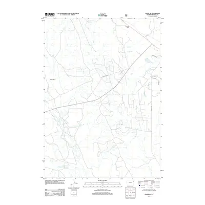
2012 Map of Osage SE
USGS Topo · Published 2012About this map
Boulden Ranch sits at the heart of this rangeland landscape south of Newcastle, where a network of ephemeral drainages and vital water catchments define the local topography. The area is characterized by an extensive system of creeks and draws, including Skull Cr, Oil Cr, and Beaver Cr, which move across a high plains environment marked by landforms like Sixmile Basin. Ranching infrastructure is central to the map's details, with several water management features such as Shostak Reservoir and Michaels Reservoir providing essential resources for livestock in this semi-arid region. Transportation is primarily facilitated by local routes like Eberspecher Rd and Morrissey Rd, which follow the section lines and natural contours of the Weston County terrain. These roads link the scattered homesteads and pastures, illustrating the sparse but organized settlement pattern typical of the eastern Wyoming prairie during the early 21st century.
Find a feature on this map
17 named features on this map. Tap any name to fly to it.
Don’t see what you’re looking for? This feature index may not catch every label — zoom into the map to look around manually.
Map Details
Editions of this 2012 Osage SE Map
This is the sole edition of this map. No revisions or reprints were ever made.
Other maps of this area

1899 · Newcastle
USGS Topo · 1:125,000

1901 · Newcastle
USGS Topo · 1:125,000

1951 · Owens
USGS Topo · 1:24,000

1951 · Newcastle
USGS Topo · 1:24,000

1951 · Morrisey NE
USGS Topo · 1:24,000

1951 · Osage SE
USGS Topo · 1:24,000

1955 · Newcastle
USGS Topo · 1:250,000

1958 · Newcastle
USGS Topo · 1:250,000
1958 · Newcastle
USGS Topo · 1:62,500
1972 · Pedro
USGS Topo · 1:24,000