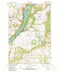
1978 Map of Osceola
USGS Topo · Published 1979About this map
The St Croix River carves a deep valley through this borderland, separating the communities of Franconia and Osceola. By the late 1970s, the landscape reflected a mix of natural preservation and local industry, with the Interstate State Park and Osceola State Fish Hatchery occupying the river's eastern banks. The river itself is dotted with features like Rock Island and backwaters such as Rice Lake and Peaslee Lake.
Find a feature on this map
33 named features on this map. Tap any name to fly to it.
Don’t see what you’re looking for? This feature index may not catch every label — zoom into the map to look around manually.
Map Details
Editions of this 1978 Osceola Map
3 editions found
Other maps of this area

1900 · St Croix Dalles
USGS Topo · 1:62,500

1901 · St Croix Dalles
USGS Topo · 1:62,500

1948 · New Richmond
USGS Topo · 1:62,500

1948 · Stillwater
USGS Topo · 1:62,500

1949 · New Richmond
USGS Topo · 1:62,500

1949 · Stillwater
USGS Topo · 1:62,500

1953 · Stillwater
USGS Topo · 1:250,000

1955 · St. Croix Dalles
USGS Topo · 1:62,500

1955 · Marine
USGS Topo · 1:24,000

1955 · Forest Lake
USGS Topo · 1:62,500