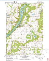
1978 Map of Osceola
USGS Topo · Published 1979About this map
The St Croix River defines the western edge of this landscape, separating Franconia on the Minnesota side from the Wisconsin settlements of Osceola and Dresser. By the late 1970s, the river valley is a hub of conservation and recreation, anchored by Interstate State Park and the Osceola State Fish Hatchery. The village of Osceola is characterized by its riverside positioning, with prominent Water Tanks and the Osceola Municipal Airfield nearby, while the Soo Line railroad provides a primary transportation corridor through the eastern terrain.
Find a feature on this map
36 named features on this map. Tap any name to fly to it.
Don’t see what you’re looking for? This feature index may not catch every label — zoom into the map to look around manually.
Map Details
Editions of this 1978 Osceola Map
3 editions found
Other maps of this area

1900 · St Croix Dalles
USGS Topo · 1:62,500

1901 · St Croix Dalles
USGS Topo · 1:62,500

1948 · New Richmond
USGS Topo · 1:62,500

1948 · Stillwater
USGS Topo · 1:62,500

1949 · New Richmond
USGS Topo · 1:62,500

1949 · Stillwater
USGS Topo · 1:62,500

1953 · Stillwater
USGS Topo · 1:250,000

1955 · St. Croix Dalles
USGS Topo · 1:62,500

1955 · Marine
USGS Topo · 1:24,000

1955 · Forest Lake
USGS Topo · 1:62,500