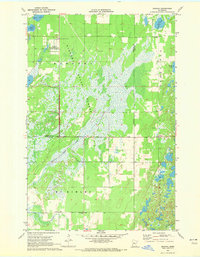
1970 Map of Oshawa
USGS Topo · Published 1972About this map
Badoura State Forest dominates this northern Minnesota landscape, where the 1970 landscape is defined by vast wetlands and timber management. The map details a specialized forestry infrastructure, including the State Nursery, a Firebreak, and the Badoura Lookout Tower. Small settlements and municipal markers like Oshawa and a Townhall sit along the county line between Hubbard and Cass counties. The hydrology of the region is particularly prominent, featuring the meandering Big Swamp Creek and several isolated water bodies such as Mow Lake, Nagel Lake, and South Haynes Lake. The transition from the rugged terrain of Bull Moose to the low-lying swamps illustrates the difficult conditions faced by early settlers and loggers in the townships of Deerfield and McKinley.
Find a feature on this map
18 named features on this map. Tap any name to fly to it.
Don’t see what you’re looking for? This feature index may not catch every label — zoom into the map to look around manually.
Map Details
Editions of this 1970 Oshawa Map
2 editions found
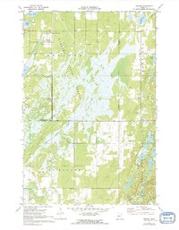
Other maps of this area

1919 · Leader
USGS Topo · 1:62,500

1953 · Brainerd
USGS Topo · 1:250,000

1957 · Brainerd
USGS Topo · 1:250,000

1958 · Brainerd
USGS Topo · 1:250,000

1965 · Brainerd
USGS Topo · 1:250,000

1969 · Burgen Lake
USGS Topo · 1:24,000

1970 · Spider Lake
USGS Topo · 1:24,000

1970 · Backus
USGS Topo · 1:24,000

1970 · Hackensack
USGS Topo · 1:24,000
1970 · Bungo Creek
USGS Topo · 1:24,000