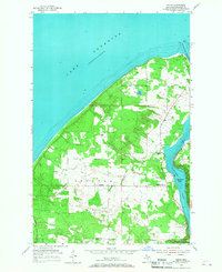
1954 Map of Oskar
USGS Topo · Published 1967About this map
Lake Superior dominates the northern coast of this Keweenaw Peninsula landscape, where the Portage Lake Ship Canal cuts through to connect the open water with Portage Lake. The interior reflects the quiet, rural character of Stanton and Adams townships during the mid-1950s. Small community clusters like Oskar and Schmidt Corner are interconnected by secondary roads, while isolated landmarks such as the Onnela Sch and Redridge Cem offer specific points of interest for genealogists tracing family roots in this part of Houghton County. The topography is defined by significant elevations like High Point and the winding course of Schlot Creek. To the south, the Salmon Trout River flows through a landscape marked by several Gravel Pits, indicating the local extraction industry of the era, while the County Hospital serves as a prominent institutional landmark near the settlement of Cole.
Find a feature on this map
22 named features on this map. Tap any name to fly to it.
Don’t see what you’re looking for? This feature index may not catch every label — zoom into the map to look around manually.
Map Details
Editions of this 1954 Oskar Map

Other maps of this area

1915 · Houghton
USGS Topo · 1:62,500

1946 · Hancock
USGS Topo · 1:24,000

1946 · Chassell
USGS Topo · 1:24,000

1946 · South Range
USGS Topo · 1:24,000

1946 · Muggun Creek
USGS Topo · 1:24,000

1948 · South Range
USGS Topo · 1:24,000
1948 · Muggun Creek
USGS Topo · 1:24,000

1948 · Hancock
USGS Topo · 1:24,000

1948 · Chassell
USGS Topo · 1:24,000

1954 · Graveraet River
USGS Topo · 1:24,000