
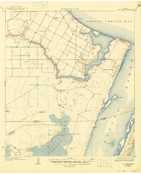
1925 Map of Oso Creek
USGS Topo · Published 1925About this map
Oso Creek winds through the coastal plains of the Texas bend, emptying into the expansive Corpus Christi Bay in this 1922 survey. The landscape reflects an early 20th-century agrarian economy, characterized by a network of rural schools like the London School and Kostoryz School, alongside essential industrial markers such as the Morgan Gin. The map reveals a transition from coastal bay environments to the inland ranching country, where working landscapes like El Camito Ranch and Portales Ranch are defined by numerous named water sources, including the Guajolote Windmill and Los Cedros Windmill. To the east, the barrier islands of Padre Island and Pita Island shield the shallow reaches of the Laguna Madre, while the Nueces Co Kleberg Co boundary line establishes the administrative divide near the interior waters of Laguna Larga.
Find a feature on this map
31 named features on this map. Tap any name to fly to it.
Don’t see what you’re looking for? This feature index may not catch every label — zoom into the map to look around manually.
Map Details
Editions of this 1925 Oso Creek Map
2 editions found
Other maps of this area

1924 · Petronilla
USGS Topo · 1:62,500

1925 · Robstown
USGS Topo · 1:62,500

1925 · Aransas Pass
USGS Topo · 1:62,500

1925 · Corpus Christi
USGS Topo · 1:62,500

1928 · Sarita
USGS Topo · 1:125,000

1950 · Corpus Christi
USGS Topo · 1:250,000

1951 · Portland
USGS Topo · 1:24,000

1951 · Corpus Christi
USGS Topo · 1:24,000

1951 · Corpus Christi
USGS Topo · 1:62,500

1951 · South Bird Island
USGS Topo · 1:24,000