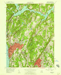
1955 Map of Ossining
USGS Topo · Published 1958About this map
The Ossining waterfront and the massive Sing Sing Prison anchor the western edge of this mid-century Westchester County survey. This period of the 1950s captures a landscape of institutional growth and suburban transition, where estates and religious retreats like the Maryknoll Seminary and the Danish Home for the Aged sit alongside developing residential centers. The New York Central railroad corridor facilitates movement between the riverfront and the interior, while the New Croton Reservoir dominates the northern terrain, managed by the New Croton Dam. Further east, the village of Chappaqua and the wooded heights of Pleasantville show the influence of the Taconic State Parkway and Saw Mill River Parkway. This sheet is particularly rich in local institutional history, documenting landmarks such as the Jennie Clarkson Society Home and the State Game Refuge.
Find a feature on this map
135 named features on this map. Tap any name to fly to it.
Don’t see what you’re looking for? This feature index may not catch every label — zoom into the map to look around manually.
Map Details
Editions of this 1955 Ossining Map
2 editions found
Other maps of this area

1892 · Stamford
USGS Topo · 1:62,500

1892 · West Point
USGS Topo · 1:62,500

1892 · Carmel
USGS Topo · 1:62,500

1892 · Tarrytown
USGS Topo · 1:62,500

1893 · Carmel
USGS Topo · 1:62,500

1893 · Stamford
USGS Topo · 1:62,500

1893 · Tarrytown
USGS Topo · 1:62,500

1894 · West Point
USGS Topo · 1:62,500

1894 · Carmel
USGS Topo · 1:62,500

1899 · Stamford
USGS Topo · 1:62,500