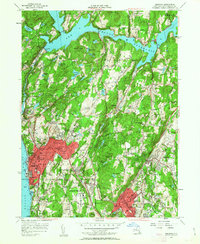
1955 Map of Ossining
USGS Topo · Published 1963About this map
Sing Sing Prison and the busy riverfront of Ossining dominate the southwestern shoreline of the Hudson River in this mid-century portrait of Westchester County. The landscape is a mix of dense residential growth and institutional presence, characterized by the sprawling Maryknoll Seminary and Kings College. Further north, the massive engineering of the New Croton Dam holds back the waters of the Croton Reservoir, a critical piece of regional infrastructure. This era captures the suburbs in transition, where established village centers like Briarcliff Manor and Pleasantville are linked by the Taconic State Parkway and the New York Central Railroad. The map also details numerous religious and social institutions, including the Mariandale property and the Edith Macy Camp, set against the backdrop of rising terrain such as Bald Mtn and Turkey Mtn.
Find a feature on this map
132 named features on this map. Tap any name to fly to it.
Don’t see what you’re looking for? This feature index may not catch every label — zoom into the map to look around manually.
Map Details
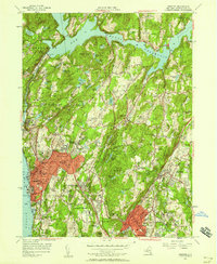
Editions of this 1955 Ossining Map
2 editions found
Other maps of this area

1892 · Stamford
USGS Topo · 1:62,500

1892 · West Point
USGS Topo · 1:62,500

1892 · Carmel
USGS Topo · 1:62,500

1892 · Tarrytown
USGS Topo · 1:62,500

1893 · Carmel
USGS Topo · 1:62,500

1893 · Stamford
USGS Topo · 1:62,500

1893 · Tarrytown
USGS Topo · 1:62,500

1894 · West Point
USGS Topo · 1:62,500

1894 · Carmel
USGS Topo · 1:62,500

1899 · Stamford
USGS Topo · 1:62,500