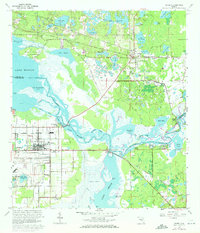
1965 Map of Osteen
USGS Topo · Published 1972About this map
The St Johns River weaves a complex network of wetlands and sloughs through the central Florida landscape in this mid-1960s survey. To the north, the settlement of Osteen is anchored by St Pauls Ch and a Radio Tower, while the southern reaches near the Sanford Airport show established residential grids in Midway and Canaan. The mapping captures a distinct transition between the high-ground settlements along the Seaboard Coast Line and the water-dominated environment of Lake Monroe. Unique local toponyms like Naked Place and Beck Hammock reflect the region's diverse terrain of hammocks and marshes. Historical researchers can trace the old rail corridor and the scattered communities of Indian Mound Village and Cameron City, while the presence of the Geneva Cem and Beardall Ave Chapel provides important points of reference for genealogical study near the shores of Lake Jessup.
Find a feature on this map
82 named features on this map. Tap any name to fly to it.
Don’t see what you’re looking for? This feature index may not catch every label — zoom into the map to look around manually.
Map Details
Editions of this 1965 Osteen Map
3 editions found
Other maps of this area

1949 · Osceola
USGS Topo · 1:24,000

1953 · Geneva
USGS Topo · 1:24,000

1955 · Orlando
USGS Topo · 1:250,000

1956 · Oviedo
USGS Topo · 1:24,000

1957 · Orlando
USGS Topo · 1:250,000

1958 · Orlando
USGS Topo · 1:250,000

1962 · Orlando
USGS Topo · 1:250,000

1962 · Casselberry
USGS Topo · 1:24,000
1964 · Orange City
USGS Topo · 1:24,000
1965 · Osteen
USGS Topo · 1:24,000