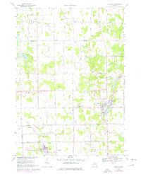
1969 Map of Otisville
USGS Topo · Published 1976About this map
Otisville serves as the central hub of this Genesee and Tuscola County borderland, where the village is situated among a cluster of glacial waters including Sand Lake, Dock Lake, and McCormick Lake. The landscape transition from the agricultural expanses of Arbela and Thetford townships into the wooded terrain of Forest is marked by numerous small-scale extractive operations, with Sandpits and Gravel Pits scattered across the northern sections.
Find a feature on this map
51 named features on this map. Tap any name to fly to it.
Don’t see what you’re looking for? This feature index may not catch every label — zoom into the map to look around manually.
Map Details
Editions of this 1969 Otisville Map
2 editions found
Other maps of this area

1920 · Flint
USGS Topo · 1:62,500

1922 · Flint
USGS Topo · 1:62,500

1943 · Flint
USGS Topo · 1:62,500

1954 · Flint
USGS Topo · 1:250,000

1958 · Flint
USGS Topo · 1:250,000

1963 · Columbiaville
USGS Topo · 1:24,000

1963 · Frankenmuth
USGS Topo · 1:24,000

1963 · Elba
USGS Topo · 1:24,000

1963 · Vassar
USGS Topo · 1:24,000

1963 · Juniata
USGS Topo · 1:24,000