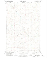
1972 Map of Otter Creek
USGS Topo · Published 1974About this map
Otter Creek meanders through this agricultural section of Oliver County, carving a valley across a landscape defined by seasonal water management and early township organization. The map captures a moment in rural North Dakota history when small-district institutions were still prominent landmarks for the surrounding farming community. Educational life is anchored by Spring Brook Sch in the north and Weber Sch further south, while local genealogy is rooted at Otter Creek Cem and Moos Cem. Technical infrastructure of the 1970s is also evident, including a Gaging Station and a major Pipeline cutting across the northeast corner. This survey serves as a record of a quiet, working landscape where the reliance on subsurface water is indicated by several labeled points including a Flowing Well and various springs.
Find a feature on this map
13 named features on this map. Tap any name to fly to it.
Don’t see what you’re looking for? This feature index may not catch every label — zoom into the map to look around manually.
Map Details
Editions of this 1972 Otter Creek Map
This is the sole edition of this map. No revisions or reprints were ever made.
Other maps of this area

1954 · Bismarck
USGS Topo · 1:250,000

1954 · McClusky
USGS Topo · 1:250,000

1958 · Bismarck
USGS Topo · 1:250,000

1958 · McClusky
USGS Topo · 1:250,000

1968 · Red Butte
USGS Topo · 1:24,000

1968 · Red Butte NW
USGS Topo · 1:24,000

1968 · Hannover NW
USGS Topo · 1:24,000

1970 · Bluegrass
USGS Topo · 1:24,000

1970 · New Salem NW
USGS Topo · 1:24,000

1970 · Hailstone Butte
USGS Topo · 1:24,000