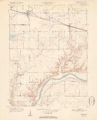
1951 Map of Otterbein
USGS Topo · Published 1951About this map
The Wabash River carves through the southern landscape of this 1951 study, where the remnants of an Abandoned Canal still follow the river's northern bank. This region, spanning the intersection of Tippecanoe, Benton, and Warren counties, is defined by its agricultural character and a dense network of early rural institutions. Small settlements like Otterbein and Montmorenci serve as focal points for the surrounding prairie, connected by the New York Central and the Chicago and New York St Louis railroads.
Find a feature on this map
38 named features on this map. Tap any name to fly to it.
Don’t see what you’re looking for? This feature index may not catch every label — zoom into the map to look around manually.
Map Details
Editions of this 1951 Otterbein Map
2 editions found
Other maps of this area

1941 · Lafayette
USGS Topo · 1:24,000

1942 · Otterbein
USGS Topo · 1:24,000

1942 · Lafayette
USGS Topo · 1:24,000

1950 · Lafayette
USGS Topo · 1:24,000

1951 · Otterbein
USGS Topo · 1:24,000

1953 · Danville
USGS Topo · 1:250,000

1955 · Danville
USGS Topo · 1:250,000

1956 · Danville
USGS Topo · 1:250,000

1961 · Chatterton
USGS Topo · 1:24,000

1961 · Romney
USGS Topo · 1:24,000