
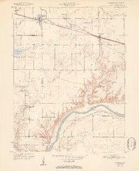
1951 Map of Otterbein
USGS Topo · Published 1951About this map
The Wabash River carves a deep valley across this mid-century landscape, marking the southern boundary of Tippecanoe and Warren Counties. This survey illustrates a contrast between the flat upland agricultural plains near Otterbein and the dissected, wooded ravines of Indian Creek and Little Pine Creek as they descend toward the river. Transportation history is deeply etched here, with the New York Central and New York Chicago and St Louis railroads converging near Montmorenci.
Find a feature on this map
48 named features on this map. Tap any name to fly to it.
Don’t see what you’re looking for? This feature index may not catch every label — zoom into the map to look around manually.
Map Details
Editions of this 1951 Otterbein Map
2 editions found
Other maps of this area

1941 · Lafayette
USGS Topo · 1:24,000

1942 · Otterbein
USGS Topo · 1:24,000

1942 · Lafayette
USGS Topo · 1:24,000

1950 · Lafayette
USGS Topo · 1:24,000

1953 · Danville
USGS Topo · 1:250,000

1955 · Danville
USGS Topo · 1:250,000

1956 · Danville
USGS Topo · 1:250,000

1961 · Chatterton
USGS Topo · 1:24,000

1961 · Romney
USGS Topo · 1:24,000

1961 · Otterbein
USGS Topo · 1:24,000