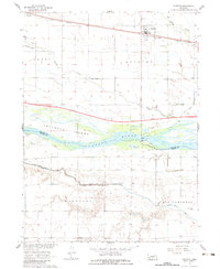
1962 Map of Overton
USGS Topo · Published 1983About this map
The Platte River corridor dominates this 1962 study, revealing a complex landscape of braided channels and expansive features like Jeffreys Island. This era captures significant infrastructure development, most notably the Interstate 80 corridor labeled as Under Construction south of the river. The Union Pacific rail line remains the primary east-west spine for the northern settlements, passing through Overton and the siding at Josselyn.
Find a feature on this map
32 named features on this map. Tap any name to fly to it.
Don’t see what you’re looking for? This feature index may not catch every label — zoom into the map to look around manually.
Map Details
Editions of this 1962 Overton Map
2 editions found
Other maps of this area

1896 · Lexington
USGS Topo · 1:125,000

1896 · Kearney
USGS Topo · 1:125,000

1899 · Lexington
USGS Topo · 1:125,000

1955 · Grand Island
USGS Topo · 1:250,000

1957 · Grand Island
USGS Topo · 1:250,000

1958 · Grand Island
USGS Topo · 1:250,000

1961 · Elm Creek West
USGS Topo · 1:24,000

1961 · Miller SW
USGS Topo · 1:24,000

1962 · Lexington SE
USGS Topo · 1:24,000

1962 · Lexington East
USGS Topo · 1:24,000
Featured Places
- Overton, NE
- Josselyn, NE
- Northside Village Mobile Home Park, Overton
- Dawson County, NE
- Phelps County, NE