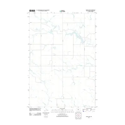
2012 Map of Owen Lake
USGS Topo · Published 2012About this map
Owen Lake sits at the center of this Perkins County landscape, serving as a primary water source for the surrounding prairie. This area of South Dakota is defined by a dendritic drainage network where Thunder Butte Cr and Cone Tree Cr carve subtle paths through the terrain. The map reveals a strictly organized section-line road system, with routes like 178th Ave and 134th St providing the essential framework for movement across this rural expanse. Local hydrology is further detailed by the presence of Smith Cr and Sickles Cr, which trace the seasonal flow patterns characteristic of the High Plains. This 2012 survey illustrates the enduring intersection of natural waterways and the rigid grid of human boundary lines that manage this cattle and wheat country.
Find a feature on this map
13 named features on this map. Tap any name to fly to it.
Don’t see what you’re looking for? This feature index may not catch every label — zoom into the map to look around manually.
Map Details
Editions of this 2012 Owen Lake Map
This is the sole edition of this map. No revisions or reprints were ever made.
Other maps of this area

1954 · Lemmon
USGS Topo · 1:250,000

1957 · Lemmon
USGS Topo · 1:250,000

1983 · Rabbit Butte
USGS Topo · 1:24,000

1983 · Boxcar Buttes
USGS Topo · 1:24,000

1983 · Square Top Butte
USGS Topo · 1:24,000

1983 · Bison
USGS Topo · 1:24,000

1983 · Sunrise Butte
USGS Topo · 1:24,000

1983 · Date NE
USGS Topo · 1:24,000

1983 · Owen Lake
USGS Topo · 1:24,000
1983 · Chance
USGS Topo · 1:24,000