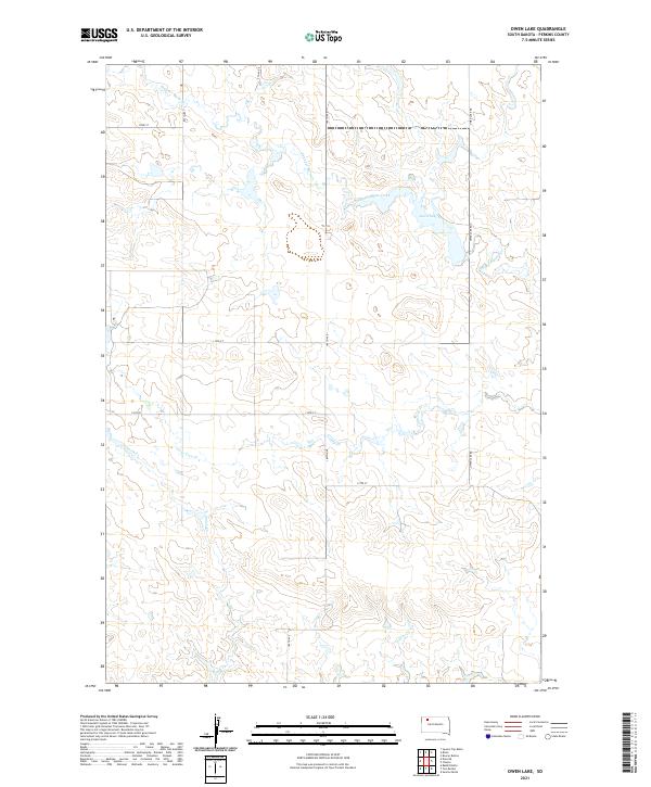
2021 Map of Owen Lake
USGS Topo · Published 2021About this map
Owen Lake and the winding drainage of Thunder Butte Creek define this section of Perkins County, South Dakota. The landscape is characterized by its intermittent watercourses and the section-line roads that impose a grid upon the rolling high plains. These drainage patterns, including Cone Tree Cr and Pickles Cr, illustrate the subtle topographic shifts that dictated ranching and land use across the West River region. The presence of Smith Cr and various branches of Thunder Butte Cr suggest a terrain where water remains the primary driver of geography. Transportation is primarily limited to gravel and dirt routes like Owen Lake Rd and 180th Ave, which connect remote holdings. This 2021 survey provides a modern baseline for tracing the enduring property lines and hydrographic features of this prairie landscape.
Find a feature on this map
20 named features on this map. Tap any name to fly to it.
Don’t see what you’re looking for? This feature index may not catch every label — zoom into the map to look around manually.
Map Details
Editions of this 2021 Owen Lake Map
This is the sole edition of this map. No revisions or reprints were ever made.
Other maps of this area

1954 · Lemmon
USGS Topo · 1:250,000

1957 · Lemmon
USGS Topo · 1:250,000

1983 · Rabbit Butte
USGS Topo · 1:24,000

1983 · Boxcar Buttes
USGS Topo · 1:24,000

1983 · Square Top Butte
USGS Topo · 1:24,000

1983 · Bison
USGS Topo · 1:24,000

1983 · Sunrise Butte
USGS Topo · 1:24,000

1983 · Date NE
USGS Topo · 1:24,000

1983 · Owen Lake
USGS Topo · 1:24,000
1983 · Chance
USGS Topo · 1:24,000