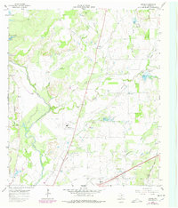
1966 Map of Owens
USGS Topo · Published 1978About this map
Owens and the developing outskirts of Early anchor this mid-1960s survey of Brown County, Texas. The landscape is defined by the winding course of Pecan Bayou and its numerous tributaries, including Elm Creek and Delaware Creek. Transportation history is visible through the Atchison Topeka and Santa Fe Railroad route and an Old Railroad Grade that cuts through the center of the sheet near Brownwood Municipal Airport. For genealogists and local historians, the map identifies several rural landmarks and family-named burial grounds, such as Heflin Cem, Staley Cem, and Jones Chapel Cem. Industrial activity is marked by various resource sites, including a Sandpit, Claypit, and scattered Gas Wells, reflecting the regional economy prior to late-century suburban expansion.
Find a feature on this map
26 named features on this map. Tap any name to fly to it.
Don’t see what you’re looking for? This feature index may not catch every label — zoom into the map to look around manually.
Map Details
Editions of this 1966 Owens Map
2 editions found
Other maps of this area

1887 · Coleman
USGS Topo · 1:125,000

1889 · Brownwood
USGS Topo · 1:125,000

1889 · Coleman
USGS Topo · 1:125,000

1894 · Brownwood
USGS Topo · 1:125,000

1924 · Coleman 1-a
USGS Topo · 1:48,000

1924 · Brownwood Reservoir Site
USGS Topo · 1:48,000

1925 · Brownwood 3-b
USGS Topo · 1:48,000

1927 · Grosvenor
USGS Topo · 1:62,500

1928 · Zephyr
USGS Topo · 1:62,500

1950 · Zephyr
USGS Topo · 1:62,500