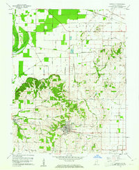
1959 Map of Owensville
USGS Topo · Published 1961About this map
Owensville serves as the central hub of this late-1950s landscape, where the flat agricultural plains of Patoka meet the more complex drainage networks of Montgomery. The region is defined by an intricate system of man-made waterways, including Lillard Ditch, Mc Carty Ditch, and Hibbinbotham Ditch, which redirect water across the Gibson County farmland. Significant historical landmarks include the Old Indian Treaty Boundary cutting across the northeastern corner, a remnant of early frontier surveying. Transportation is anchored by several major rail lines, such as the Southern and the Chicago and Eastern Illinois, which facilitated the movement of goods between rural outposts like Lyles and Johnson. Local genealogy is well-preserved through numerous family-named landmarks like Skelton Cemetery and Sand Hill Church.
Find a feature on this map
50 named features on this map. Tap any name to fly to it.
Don’t see what you’re looking for? This feature index may not catch every label — zoom into the map to look around manually.
Map Details
Editions of this 1959 Owensville Map
Other maps of this area

1901 · Princeton
USGS Topo · 1:62,500

1901 · Haubstadt
USGS Topo · 1:62,500

1903 · Haubstadt
USGS Topo · 1:62,500

1903 · New Harmony
USGS Topo · 1:62,500

1903 · Princeton
USGS Topo · 1:62,500

1903 · Patoka
USGS Topo · 1:125,000

1904 · Mount Carmel
USGS Topo · 1:62,500

1938 · New Harmony
USGS Topo · 1:62,500

1956 · Vincennes
USGS Topo · 1:250,000

1957 · Vincennes
USGS Topo · 1:250,000