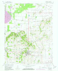
1959 Map of Owensville
USGS Topo · Published 1981About this map
Owensville serves as the primary hub of this southwestern Indiana landscape, where the grid-like agricultural plains of Patoka township meet the more broken terrain of Montgomery. A notable historical artifact of the early nineteenth century is visible in the north, where the Old Indian Treaty Boundary cuts diagonally across the township lines. This line, combined with the presence of the Southern and Louisville and Nashville railroads, illustrates the evolution of land use from early frontier agreements to the established transportation networks of the mid-twentieth century.
Find a feature on this map
45 named features on this map. Tap any name to fly to it.
Don’t see what you’re looking for? This feature index may not catch every label — zoom into the map to look around manually.
Map Details
Editions of this 1959 Owensville Map
Other maps of this area

1901 · Princeton
USGS Topo · 1:62,500

1901 · Haubstadt
USGS Topo · 1:62,500

1903 · Haubstadt
USGS Topo · 1:62,500

1903 · New Harmony
USGS Topo · 1:62,500

1903 · Princeton
USGS Topo · 1:62,500

1903 · Patoka
USGS Topo · 1:125,000

1904 · Mount Carmel
USGS Topo · 1:62,500

1938 · New Harmony
USGS Topo · 1:62,500

1956 · Vincennes
USGS Topo · 1:250,000

1957 · Vincennes
USGS Topo · 1:250,000