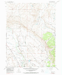
1955 Map of Owl Ridge
USGS Topo · Published 1990About this map
The Illinois River and its numerous tributaries dominate this high-altitude landscape in Jackson County, where an intricate network of irrigation channels supported early 20th-century ranching operations. The map documents a specialized hydraulic economy, featuring several family-named outposts such as Burr Ranch, Vils Ranch, and the Illinois Ranch. Water management is the primary human imprint on the land, evidenced by an extensive system of ditches including the Pioneer Ditch, Midland Ditch, and Overland Ditch. These man-made watercourses connect larger water bodies like the Thirty one Reservoir and Rand Reservoir. The terrain transitions from the alluvial plains of the river valley up toward the prominent geological formations of Owl Ridge and Owl Mountain. Industrial activity is represented by the Gravel Pits located near the riverbank, while the presence of the Ish Baldwin road suggests early transit routes through the area.
Find a feature on this map
39 named features on this map. Tap any name to fly to it.
Don’t see what you’re looking for? This feature index may not catch every label — zoom into the map to look around manually.
Map Details
Editions of this 1955 Owl Ridge Map
5 editions found
Other maps of this area

1954 · Craig
USGS Topo · 1:250,000

1955 · Gould
USGS Topo · 1:24,000

1955 · Owl Ridge
USGS Topo · 1:24,000

1955 · Gould NW
USGS Topo · 1:24,000

1955 · Walden
USGS Topo · 1:24,000

1955 · Mac Farlane Reservoir
USGS Topo · 1:24,000

1955 · Walden
USGS Topo · 1:62,500

1956 · Johnny Moore Mountain
USGS Topo · 1:24,000

1956 · Jack Creek Ranch
USGS Topo · 1:24,000

1956 · Buffalo Peak
USGS Topo · 1:24,000