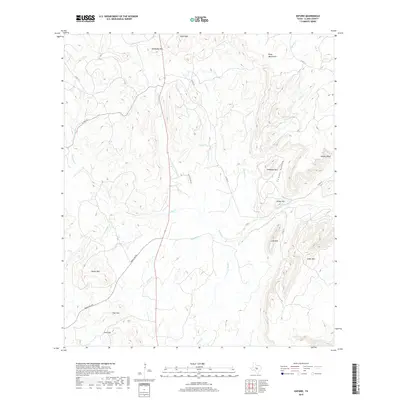
2019 Map of Oxford
USGS Topo · Published 2019About this map
The Riley Mountains dominate this central Texas landscape, characterized by a complex network of seasonal creeks and distinctive granite and limestone uplifts. High points such as Lone Mtn, Cedar Mtn, and the curiously named Potato Hill create a rugged topography defined by narrow gaps and steep bluffs. Drainage patterns are intricate, with Sandy Cr serving as a primary artery for numerous tributaries like Crump Cr and Johnson Cr. The map reveals a sparsely populated ranching region where transit is limited to routes like Ranch Rd 965 and the winding Lost Hollow Rd. Historical water sources, such as Raab Spring beneath the peaks, highlight the critical nature of water in this arid terrain. Landmarks like Fool Gap and Hickory Bluff serve as primary navigational anchors in a territory shaped more by its geology than by dense settlement.
Find a feature on this map
34 named features on this map. Tap any name to fly to it.
Don’t see what you’re looking for? This feature index may not catch every label — zoom into the map to look around manually.
Map Details
Editions of this 2019 Oxford Map
This is the sole edition of this map. No revisions or reprints were ever made.
Other maps of this area
1887 · Llano
USGS Topo · 1:125,000
1894 · Fredericksburg
USGS Topo · 1:125,000
1894 · Llano
USGS Topo · 1:125,000
1904 · Llano
USGS Topo · 1:125,000
1909 · Llano
USGS Topo · 1:125,000
1918 · Llano
USGS Topo · 1:125,000
1954 · Llano
USGS Topo · 1:250,000
1955 · Llano
USGS Topo · 1:250,000
1956 · Llano
USGS Topo · 1:250,000
1960 · Scotts Crossing
USGS Topo · 1:24,000