
1904 Map of Oxford
USGS Topo · Published 1904About this map
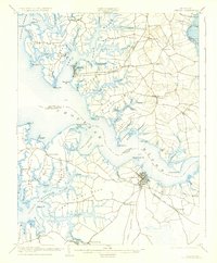
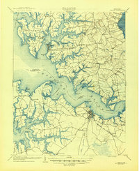
Cambridge serves as the prominent hub on the south shore of the wide Choptank River, anchoring a landscape defined by deep tidal inlets and historic waterfront settlements. This early century survey illustrates the intricate maritime geography of Talbot and Dorchester counties, where life centered on the water and the Ferry connection between Bellevue and Oxford. The inland infrastructure is dominated by the Delaware and Chesapeake and the Cambridge and Seaford rail lines, which linked the agricultural interior to crucial landing points like Trappe Sta. and the shipping docks at Travers Whf. and Kirby Whf.
Find a feature on this map
101 named features on this map. Tap any name to fly to it.
Don’t see what you’re looking for? This feature index may not catch every label — zoom into the map to look around manually.
Map Details
Editions of this 1904 Oxford Map
3 editions found
Other maps of this area

1892 · Drum Point
USGS Topo · 1:62,500

1892 · Annapolis
USGS Topo · 1:62,500

1893 · Sharps Island
USGS Topo · 1:62,500

1898 · Choptank
USGS Topo · 1:125,000

1898 · St. Marys
USGS Topo · 1:125,000

1901 · Drum Point
USGS Topo · 1:62,500

1903 · Nanticoke
USGS Topo · 1:62,500

1904 · St. Michaels
USGS Topo · 1:62,500

1904 · Annapolis
USGS Topo · 1:62,500

1904 · Sharps Island
USGS Topo · 1:62,500